

BRAINERD STREET VIEWS
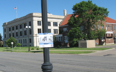 |
| Laurel Street 2017 Source: John Van Essen |
The following photos have been made into 12x12 inch signs using a grant from the Clean Water Land & Legacy Amendment obtained through the efforts of Jolene Bradley of the Brainerd Public Library. The photos have been hung on various corresponding streets in the city of Brainerd starting on Laurel Street.
All of the signs have a QR code. When you scan that code using a QR Code Reading App on a smart phone, you will be directed to this web page, where you can learn more details about what is shown in each photo.
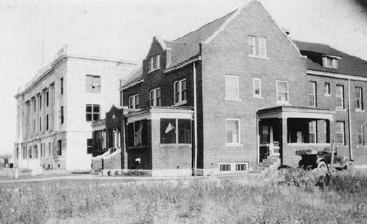 |
| Laurel Street ca. 1920s Source: Crow Wing County Historical Society |
The Crow Wing County Jail and Courthouse, ca. 1920s. Both the county jail and county courthouse were designed by architects, Alden & Harris of St. Paul. The county jail, completed in 1917, was added to the National Register of Historic Places in 1980, becoming the Crow Wing County Historical Society Museum in 1983. The courthouse was completed in 1920.
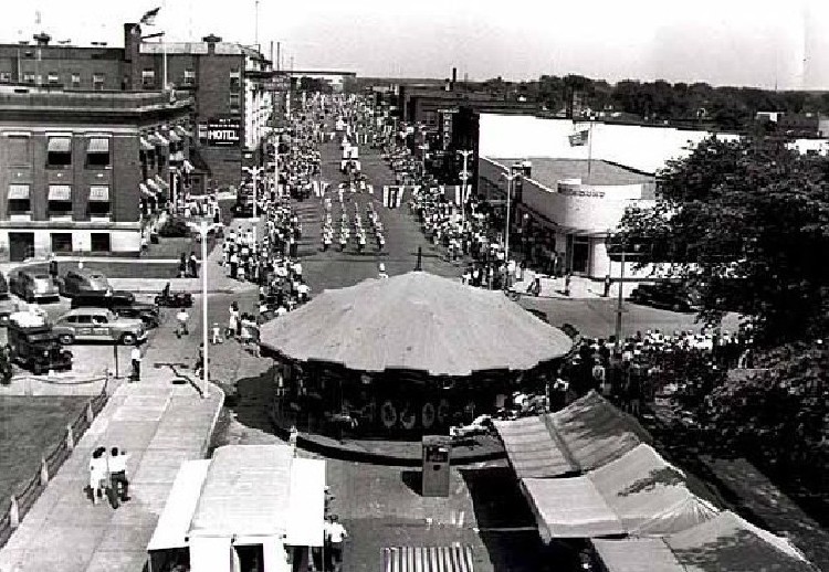 |
| Laurel Street 1946 Source: Crow Wing County Historical Society |
Looking east on Laurel Street. The first building on the right is the Greyhound Bus Depot built in 1945 and the only Moderne architectural style building in the city, across the street to the north is the City Hall and the large building on the left, east of the City Hall, is the Iron Exchange Building. The crowd is celebrating Brainerd’s Diamond Jubilee.
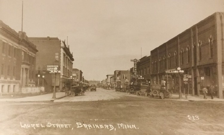 |
| Laurel Street ca. 1930s Source: Crow Wing County Historical Society |
Looking east on Laurel Street from the intersection of South 5th Street. The first building on the left is the City Hall built in 1914-1915, next is the Iron Exchange Building built in 1910-1911 and burned on July 22, 1970. On the right, the first building is the Gardner Block built in 1891 by George Gardner and in the distance is the Lively Garage built in 1919.
 |
| Fifth Street 1936 Source: Crow Wing County Historical Society |
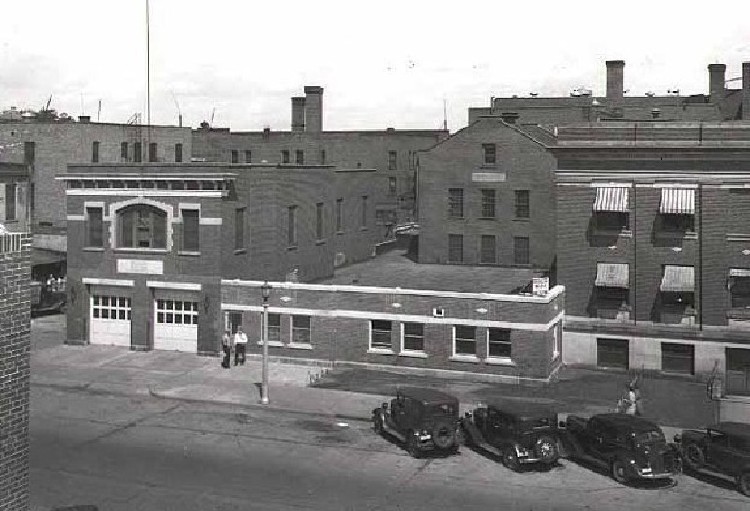
Looking northeast near the corner of South 5th Street. The first building on the right is the City Hall, built in 1914-1915; the second building is the Fire Hall built in 1914-1915, with a later addition connecting it to the City Hall. The building behind the Fire Hall addition is the City Jail built in 1914-1915. Alden & Harris were the architects for the City Hall, Fire Hall and City Jail built in 1914-15, the Crow Wing County Jail built in 1916-1917 and the Crow Wing County Courthouse built in 1919-1920.
 |
| Laurel Street ca. 1930s Source: Minnesota Historical Society |
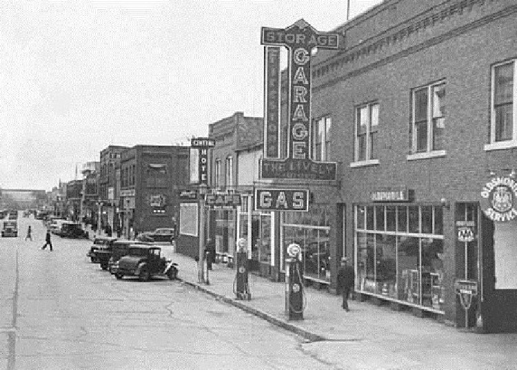
Looking southeast on Laurel Street. The building is the W. E. Lively Garage built in 1919.
 |
| Laurel Street ca. 1940s Source: Crow Wing County Historical Society |
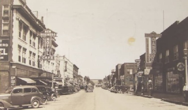
Looking east on Laurel Street from South 5th Street. On the left is the Iron Exchange Building built 1910-1911 and burned July 22, 1970, across South 6th Street is the Elks Building built in 1926 and down the block at the northwest corner of Laurel and South 7th Streets is the Parker Block built in 1908.
 |
| Laurel Street 1938 Source: Crow Wing County Historical Society |
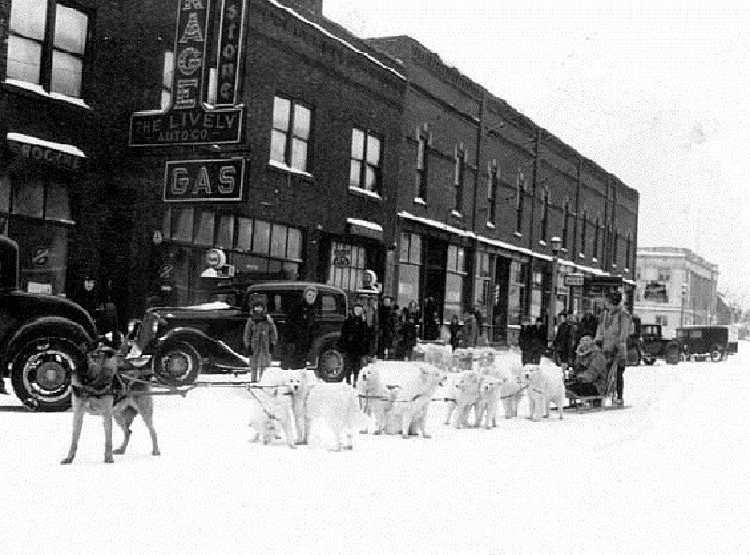
Looking southwest on Laurel Street showing the Winter Carnival dog sled team in front of the W. E. Lively Garage built in 1919, the next building is the Gardner Block built in 1891 by George Gardner and further down the street is the Crow Wing County Courthouse built in 1919-1920.
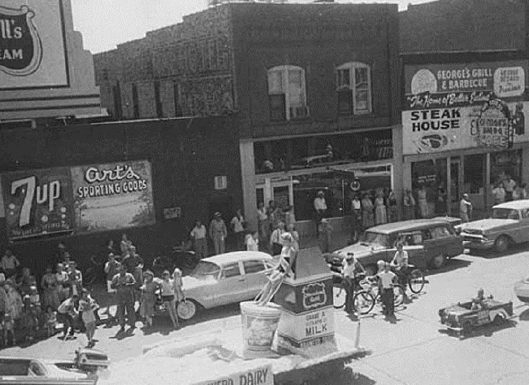 |
| Laurel Street 1958 Source: Crow Wing County Historical Society |
Looking southeast from the top of the Iron Exchange Building showing a parade on Laurel Street near the intersection of South 6th Street.
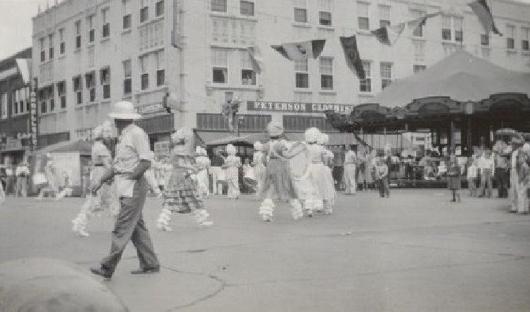 |
| Laurel Street 1939 Source: Crow Wing County Historical Society |
Looking northeast from the intersection of Laurel and South 6th Streets. The Elks Building with the Brainerd Daily Dispatch Building on the left. The Brainerd Ladies’ Drum and Bugle Corps is marching during the Paul Bunyan Exposition parade in their 1890’s costumes, which they made themselves.
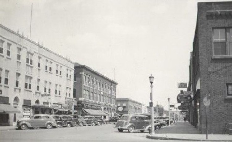 |
| Laurel Street ca. 1930s Source: Crow Wing County Historical Society |
Looking northeast from the intersection of South 6th and Laurel Streets. The Elks Building built in 1926 is on the left, next is the Parker Block built in 1908 and in the distance is the Koop Block built in 1922. On the right is the Coast-to-Coast Hardware Store, built in 1914 to accommodate the Columbia Theater which seated 550. The theater was decorated in rose and gold; the ushers wore red uniforms trimmed in black braid and gold letters.
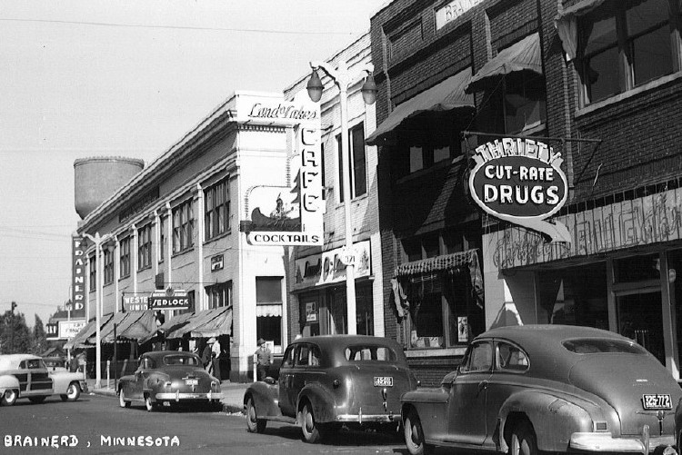 |
| Sixth Street ca. 1940s Source: Crow Wing County Historical Society |
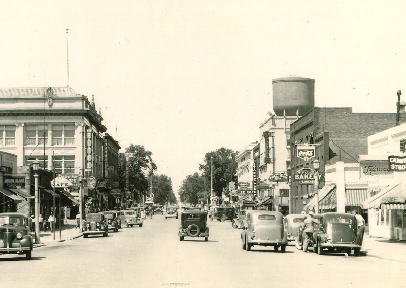
Looking northeast on South 6th Street. The first building on the right is the Thrifty Cut-Rate Drugstore, next the Brainerd Daily Dispatch Building, next the Land O’Lakes Cafe, the First National Bank, the Brainerd Theater and the water tower on Washington and South 6th Streets.
 |
| Sixth Street ca. 1903 Source: Crow Wing County Historical Society |
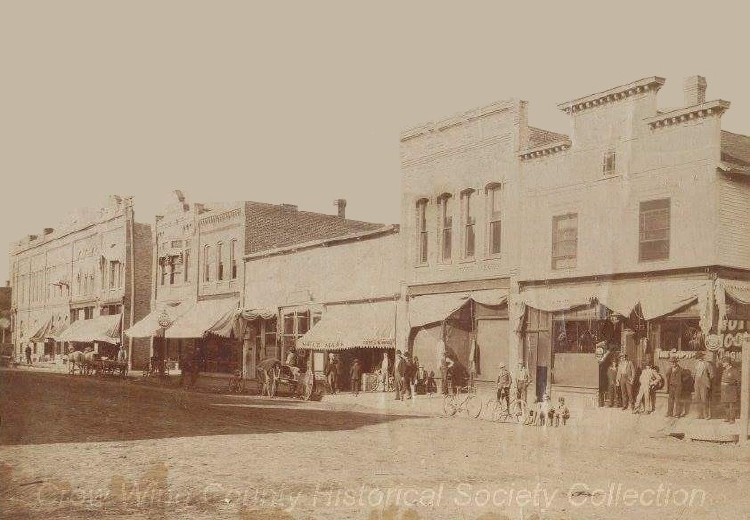
Looking northeast on South 6th Street. Buildings left to right are the First National Bank Building, Dressen Block at 213, the Brainerd Daily Dispatch Building at 215, Svea Saloon at 217, Paine & McGinn Meat Market at 219, Trades & Labor Assembly Hall, Andrew Lagerquist Tailor at 221, Andrew H. Moberg Saloon at 223, built by Andrew P. Farrar in 1897 is where the Elks building is now.
 |
| Laurel Street 1955 Source: Crow Wing County Historical Society |
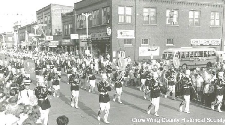
Looking southeast on Laurel Street from the corner of South 6th Street. The building on the right is the Coast-to-Coast Hardware Store. This building was originally known as the Hayes Block built in 1914 by J. M. Hayes. Over the years the building housed the Columbia, Best and Lyceum Theaters; eventually becoming the Coast-to-Coast Hardware Store, a radio station, etc.
 |
| Sixth Street 1912 Source: Crow Wing County Historical Society |
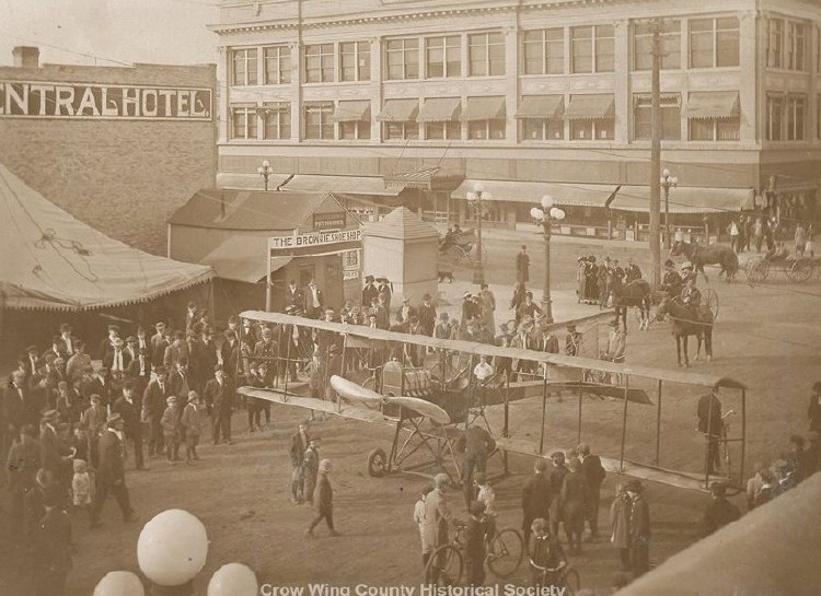
Looking northwest at the corner of South 6th and Laurel Streets. The large building on the right is the Iron Exchange Building built in 1910-1911 and burned on July 22, 1970. The building on the left is the Central Hotel. The small building labeled “The Brownie Shoe Shop” also contains the Andrew P. Nelson photography studio. According to Gary Liming, airplane historian and author, of St. Louis, there was only one aircraft of this model, which was the Type XII, No. 30, Tractor biplane. Dr. Frank M. Bell, the plane’s pilot, referred to it as his "military tractor" and this model was the first U. S. designed tractor aircraft. It used a Roberts 6X engine and was built in 1912 by Thomas Benoist in St. Louis. The Tractor was the first aircraft designed in the U. S. which placed the propeller and engine in front of the pilot so that the aircraft was pulled through the air by the propeller—all other U. S. designed planes at the time, ie. Curtiss or Wright airplanes, were pushed through the air. There is a surviving Type XII hanging in the Smithsonian's Udvar-Hazy museum near Washington, D. C.
 |
| Sixth Street ca. 1940s Source: Crow Wing County Historical Society |
Looking north on South 6th Street from near the corner of Maple Street. On the left behind the car is the Sherlund Building. The large building is the Iron Exchange Building built in 1910-1911 on the corner of Laurel and South 6th Streets. On the right is the water tower, completed in 1920, on the corner of Washington and South 6th Streets.
 |
| Sixth Street ca. 1920s Source: Crow Wing County Historical Society |
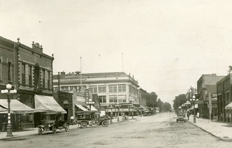
Looking north on South 6th Street between Maple and Laurel Streets. The first building on the left is the Lagerquist Block housing the Ericson Bakery, next is the Miracle Block built in 1904 by Harmidas Turcotte and housing Turcotte & Sons Grocery—it was called the Miracle Block by Julia, Harmidas’ wife, she said it would be a “miracle” if it was built; the next building is the Sherlund Building and the large building on the left is the Iron Exchange Building built in 1910-1911.
 |
| Laurel Street ca. 1940s Source: Crow Wing County Historical Society |
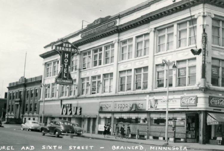
Looking northwest from the corner of Laurel and South 6th Streets. The building is the Iron Exchange Building built in 1910-1911 by W. D. McKay. It eventually houses the New Brainerd Hotel, the Vogue Supper Club, the Dugout Bar, the Korner Kut Rate Drugstore, the F. W. Woolworth Store and King’s Sporting Goods. The building burned on July 22, 1970.
 |
| Laurel Street ca. 1910s Source: Crow Wing County Historical Society |
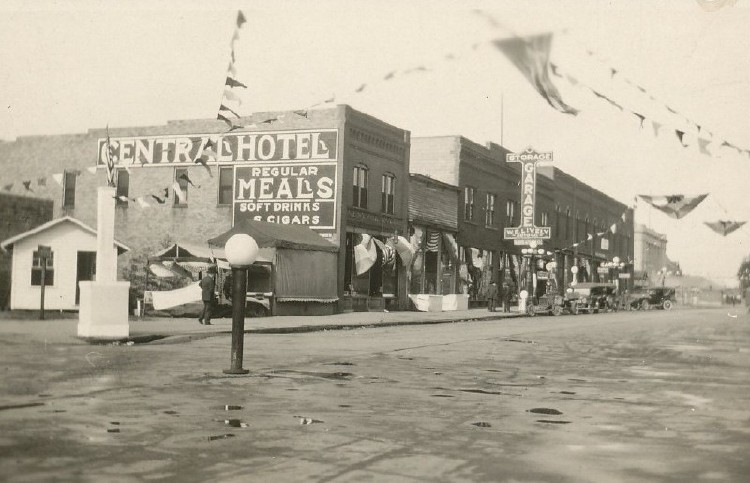
Looking southwest on Laurel Street from near the corner of South 6th Street. The large building on the left is the Central Hotel. Further down the block is the W. E. Lively Garage built in 1919.
 |
| Laurel Street ca. 1960s Source: Crow Wing County Historical Society |
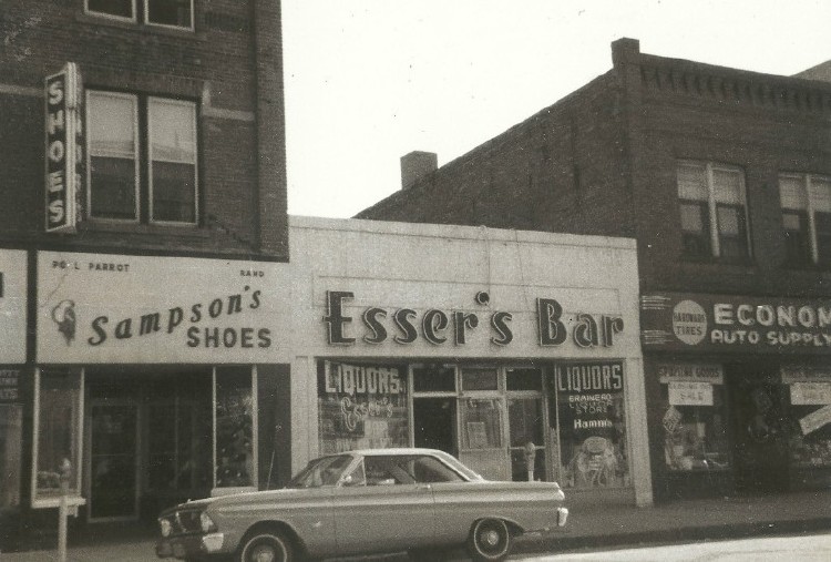
Looking southwest on Laurel Street mid-block between South 6th and South 7th Streets showing Sampson’s Shoe Store, Esser's Bar and Economy Auto Parts.
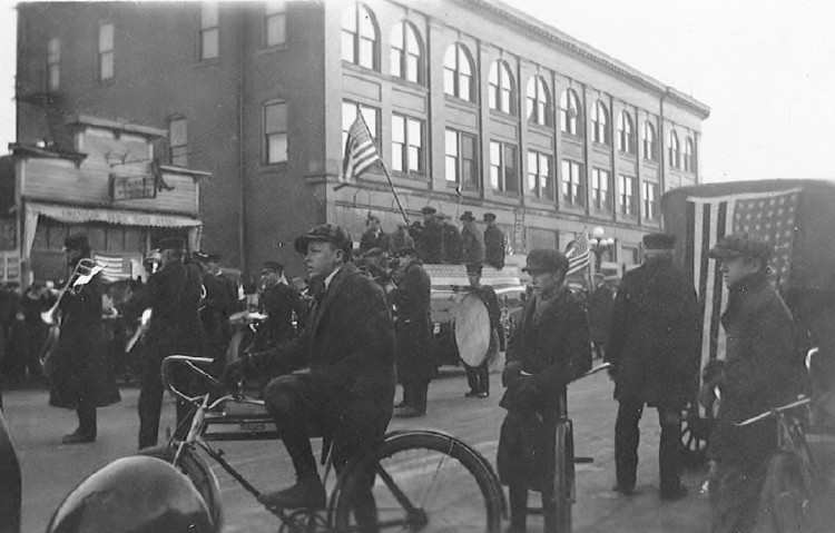 |
| Laurel Street 1918 Source: Crow Wing County Historical Society |
Looking northeast on Laurel Street. The large building is the Parker Block built in 1908. The parade was held to celebrate the end of World War I on November 11, 1918; the Brainerd City Band is in the background.
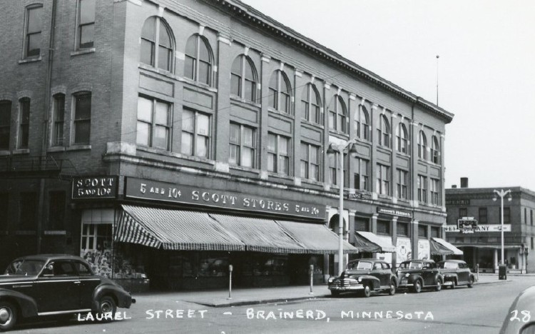 |
| Laurel Street ca. 1930s Source: Crow Wing County Historical Society |
Looking northeast on Laurel Street. The building is the Parker Block, housing the Scott Store which arrived in Brainerd in 1929. Across the street on the corner is the Koop Block built in 1922, which housed the J. C. Penney Company arriving in Brainerd in 1923.
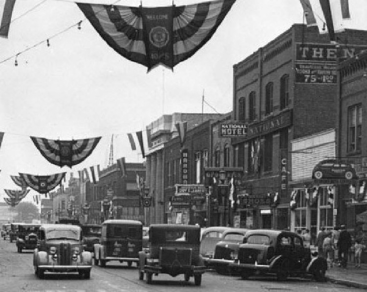 |
| Laurel Street ca. 1940s Source: Crow Wing County Historical Society |
Looking southeast on Laurel Street from near the corner of South 6th Street. Two of the buildings shown on the right are the National Hotel and the Citizens State Bank; the Alderman-Maghan Hardware store is also in this block.
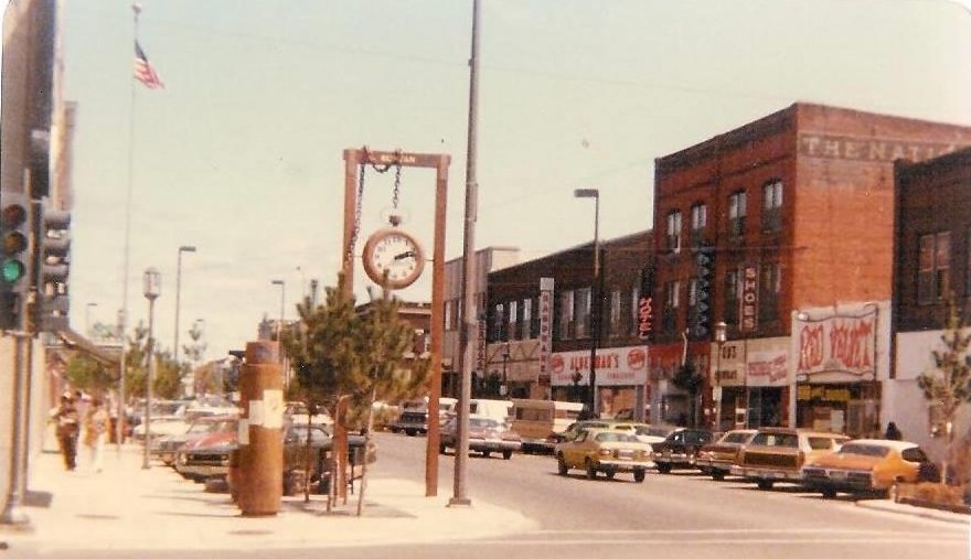 |
| Laurel Street ca. 1964-65 Source: Julie Nesheim |
Looking southeast from the intersection of South 6th and Laurel Streets. The Red Velvet Lounge, National Hotel Building, Alderman’s Hardware and on the corner, Opal Ann’s Closet.
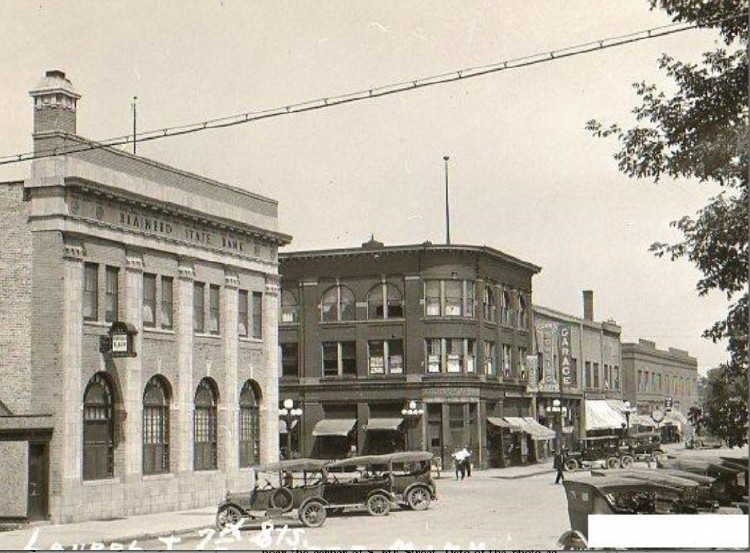 |
| Seventh Street ca. 1920s Source: Crow Wing County Historical Society |
Looking northwest from mid-block on South 7th Street, the first building on the left is the Brainerd State Bank, built in 1922. In May 1927 the Citizens State Bank bought the building and moved south across Laurel Street. Across the street to the north is the original Citizens State Bank located in the Parker Block built in 1908 by Charles N. Parker.
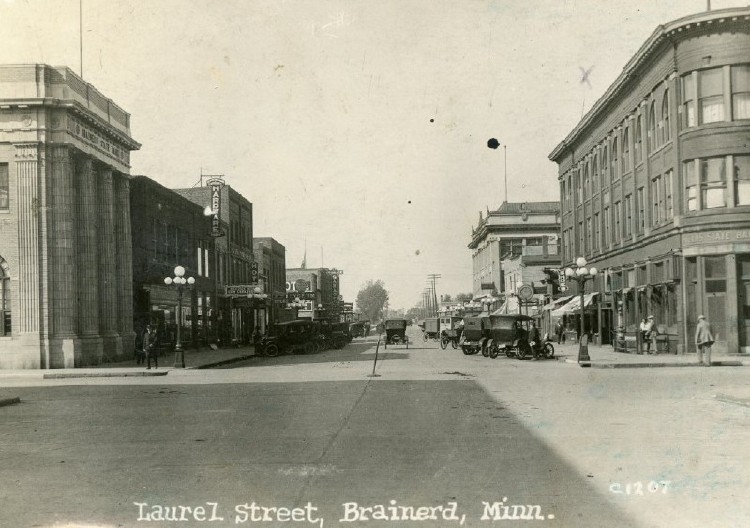 |
| Laurel Street ca. 1920s Source: Crow Wing County Historical Society |
Looking west on Laurel St. from the intersection of South 7th Street. On the left is the Brainerd State Bank built in 1922. Carl Zapffe, Sr. was the president and Henry E. Kundert was the principal stockholder and Cashier. On April 11, 1924 Henry Kundert was found nearly unconscious by his wife in his running car, located in his garage. Bank depositors thought it was an attempted suicide thereby starting a run on the bank. The bank was closed and its assets were liquidated on April 18, 1924. In May of 1927 the Citizens State Bank bought the building and moved south across the street. On the right is the original Citizens State Bank built in 1908 in the Parker Block by Charles N. Parker. In the distance on the right is the Iron Exchange Building built in 1910-11.
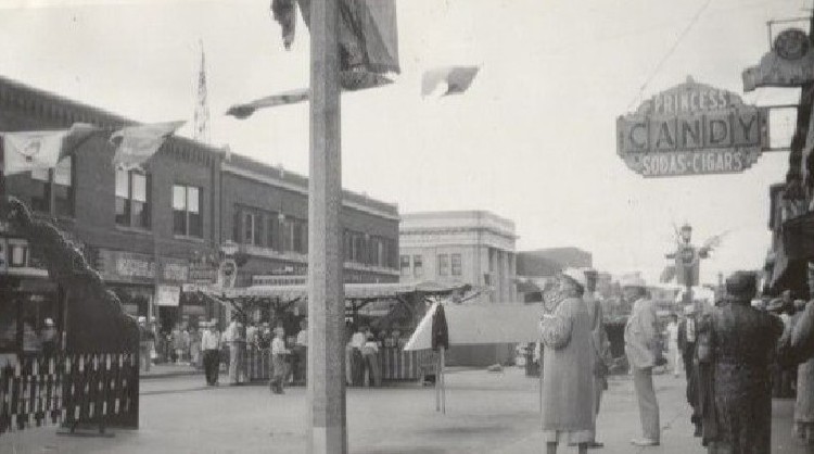 |
| Laurel Street ca. 1930s Source: Crow Wing County Historical Society |
Looking southwest on Laurel Street from mid-block. The Princess Candy Kitchen owned by Gust Holevas is on the right. The last building on the left before crossing South 7th Street to the Citizens State Bank is the Juel Block which replaced the Imperial Block burned in 1924. The building was rebuilt by Con O’Brien who named the block for his daughter, Juel. The Citizens State Bank building was built in 1922 and became the Citizens State Bank in 1927.
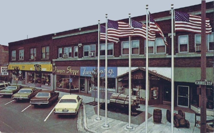 |
| Laurel Street ca. 1970s Source: Sharon Christian, Postcard |
Looking southeast on Laurel Street from near the corner of South 7th Street. The former home of Sande’s Bar & Grille is the first building on the right, owned by Don Sande; next is the Old Singer Sewing Center; next is Lundborg’s Jewelry, owned by Margaret Lundborg Larson; next is the Frances Shoppe, a higher-end women’s clothing store, owned by Ida E. Bleckert, the Frances Shoppe moved to the Brainerd Mall in October of 1987; next is Tom’s Pet and Hobby.
 |
| Laurel Street ca. 1900s Source: Crow Wing County Historical Society |
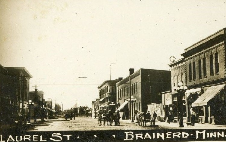
Looking west on Laurel Street from near the corner of South 8th Street. The third large building on the right is the Koop Block built in 1900 by brothers, Severin and John W. Koop; it burned in 1911 and was rebuilt in 1922. Across South 7th Street to the west is the Parker Block built in 1908.
 |
| Laurel Street ca. 1916 Source: Crow Wing County Historical Society |
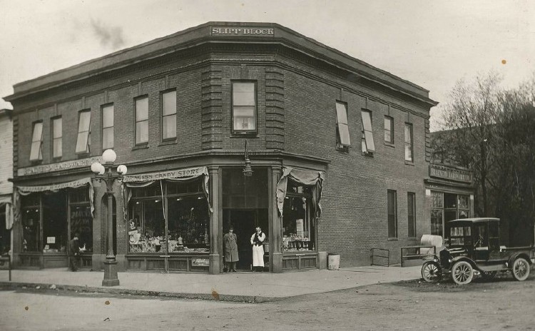
Looking northwest at the corner of Laurel and South 8th Streets. The building is the Slipp Block built by Edgar P. Slipp; this photo shows the Princess Candy Kitchen on the far left. Later the building houses Elvig’s Pharmacy.
 |
| Laurel Street ca. 1950s Source: Carol Specht Wermter |
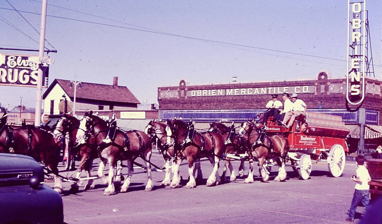
This view of the Budweiser Clydesdales is looking northeast at the corner of Laurel and South 8th Street. In the background, Elvig's Drug Store, the Broadway Cafe and O'Brien's Department Store can be seen.
 |
| Front Street 1901 Source: Crow Wing County Historical Society |
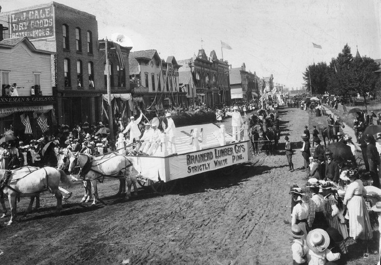
Looking southwest on Front Street between South 7th and South 6th Street. The Brainerd Lumber Company float is turning from Front Street onto South 7th Street during the Labor Day parade. A large pyramid had been erected and on its sides were hung shingles and the different kinds and grades of lumber. On the top of the pyramid was a large log which had been hollowed at the top in which cavity flowers had been placed. Corner posts were placed about the pyramid with ropes running from pole-to-pole. The entire exhibit was painted an immaculate white. The float took first prize for the best business float.
28-FRONT STREET ca. Early 1900s
 |
| Front Street ca. Early 1900s Source: Crow Wing County Historical Society |
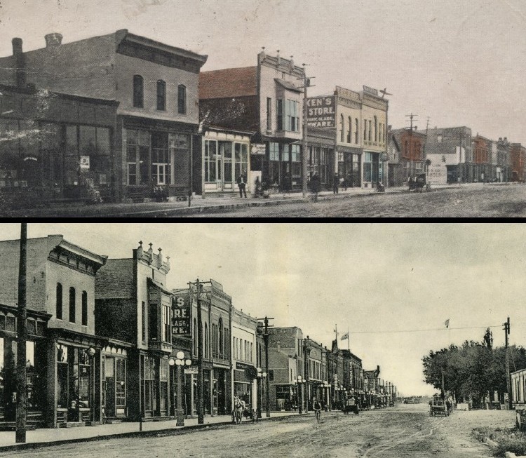
In 1903 the buildings shown in the photo are the following: Looking southwest on Front Street between South 8th and South 7th Streets. Left to right: 720 Losey & Dean (Undertakers), built in 1888; 718 Scandia Shoe Store (O. S. Hendrickson & Company); 716 P. M. Zakariasen (Tailor), sign advertises the Ingersoll Pocket Watch; 714 Davis Music House (Pianos), built ca. 1880; 712 Herbst & Betzold (Saloon); 710 Fred Luken (The Fair), built in 1889, housing his stock of “notions and fancy goods.”; 708 Dennis B. Mahoney’s Bakery in 1896, W. J. Wedell Bakery in 1903, in 1931 this building was remuddled and became the Palace Theatre, then became the current American Legion; 706 A. P. Reymond (Jeweler, Optician, Watchmaker); 704 Richard Parker (Dry Goods), in 1908 Parker replaced this building with the white pressed brick building, which became Murphy’s Dry Goods; 702 Northern Pacific Bank Block, later the Cullen Block.
Between South 7th and South 6th Streets. Left to right: 624 Linneman & Carlson (Clothing, Shoes, Gents’ Furnishings and Trunks); 618-622 Cale Block (Dry Goods), Johnson’s Pharmacy; 614-616 L. M. Koop (Dry Goods, Clothing, Boots and Shoes, Gents’ Furnishings and Cloaks). Burned in 1903 and rebuilt by Elizabeth M. Koop and became the Walverman Block.; 614 1/2 Frank Ady (Insurance, Real Estate & Loans), Z. J. Le Blanc (Agent, International Correspondence Schools), C. L. Burnett (Jeweler); 616 1/2 L. F. Hohman (Confectioner, Ice Cream Parlor, News Depot); 612 Caroline Grandelmyer (Millinery Shop); 612 1/2 Louis LaJoie (Barber); 608-610 Sleeper Block (Brainerd Dispatch), H. I. Cohen (Dry Goods, Cloaks, Notions), later becoming the Grand Theatre; 606 R. J. Holden (Saloon); 604 H. P. Dunn & Co. (Central Drug Store); 602 First National Bank Block. (1903 Brainerd City Directory)
 |
| Front Street ca. 1938 Source: Crow Wing County Historical Society |
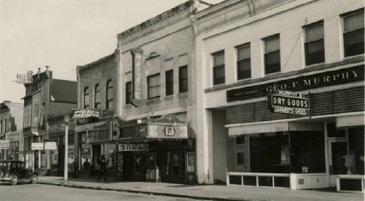
Looking southeast on Front Street. The first building on the right is Murphy’s Dry Goods Store; the second building on the right is the Palace Theater built in 1931, now the American Legion. The Palace seated 475 and boasted an English decor featuring six bungalows with flower boxes, bridges and blue skies. The stage was framed in amber satin with maroon and gold valances. In 1896 this building was a bakery.
 |
| Front Street 17 October 2017 Source: Carl Faust |
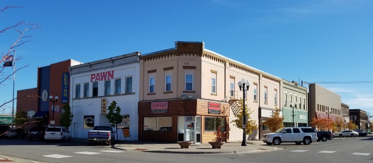
Looking southeast at the corner of Front and South 7th Street. From left to right on Front Street are the American Legion, what was once Murphy’s Dry Goods Store, now a pawn shop and the Cullen Block. On South 7th Street are the Cullen Block, Reilly Block, what once was the Phillips-Beare Block housing the S & L Department Store, Gruenhagen Block once housing the A & P Grocery Store and the Koop Block, once housing the J. C. Penney Department Store.
 |
| Seventh Street ca. 1910s Source: Crow Wing County Historical Society |
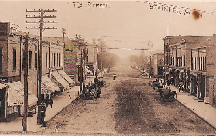
Looking south on South 7th Street. The first building on the left is the Cullen Block containing the Bye & Peterson, Gents Clothing Store and the Bell Telephone Company; next is M. J. Reis, Dry Goods, Shoes and Gents Furnishings; George Moody, Court Reporter; M. J. Reilly, Wholesale Cigars; Brockway & Parker, Grocers; H. F. Michael Company, Dry Goods & Garments; Slipp-Gruenhagen Company, Hardware, Plumbing, Heating and Bicycles; Brainerd State Bank.
On the right is John Mann, Groceries and Provisions; C. M. Patek, Furniture, Wallpaper and Carpets; E. C. Bane, Meat Market; and Johnson’s Pharmacy in the Parker Block.
 |
| Front Street ca. 1920s Source: Crow Wing County Historical Society |
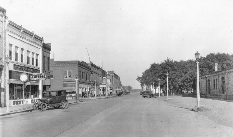
Looking west on Front Street. The building on the left is Murphy’s Dry Goods Store built in 1905 by Richard Parker and purchased in 1914 by George Murphy; the building on the right is the Northern Pacific Freight Depot built in 1902.
 |
| Front Street ca. 1950s Source: Crow Wing County Historical Society |
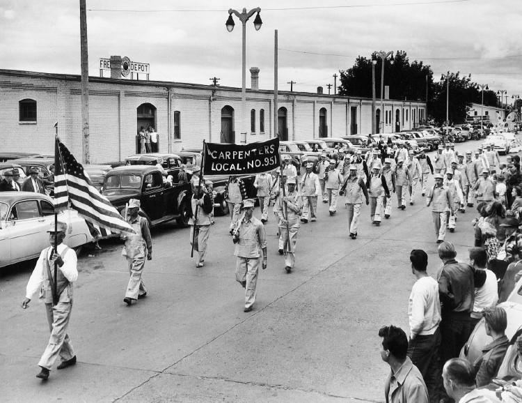
Looking northeast on Front Street near the corner of South 7th Street. The parade appears to be a Labor Day Parade; those marching are members of Carpenter’s Union Local 951. The building in the background is the Northern Pacific Freight Depot built in 1902.
 |
| Front Street ca. 1910s Source: Crow Wing County Historical Society |
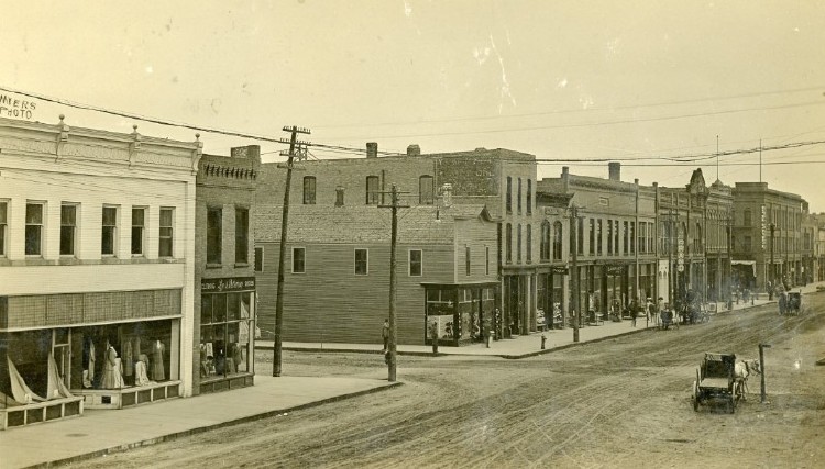
Looking southwest on Front Street at the corner of Front and South 7th Street. The first building on the left is Murphy’s Dry Goods Store, next on the corner is the Cullen Block. The Sleeper Block and the First National Bank buildings can be seen in the distance near the corner of Front and South 6th Streets.
 |
| Front Street ca. 1930s Source: Crow Wing County Historical Society |
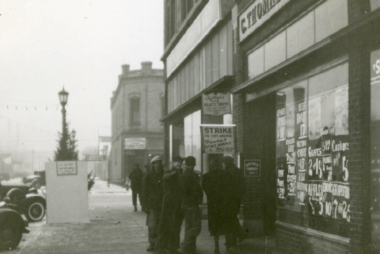
Looking east on Front Street near the corner of South 7th Street showing retail clerks on strike in front of the C. Thomas Food Market. Here is an advertisement from the Brainerd Daily Dispatch on June 10, 1937: C. Thomas—Your Up-to-Date Food Market! Fancy Salmon - 1 lb. flat can 19 cents; California New Potatoes - 10 lbs. 25 cents; Paulson's Butter - 2 lb. tub 63 cents; Choice Beef Chuck Roast - lb. 18 cents; Armour's Smoked Picnic Hams - lb. 21 cents.
 |
| Front Street ca. 1910s Source: Crow Wing County Historical Society |
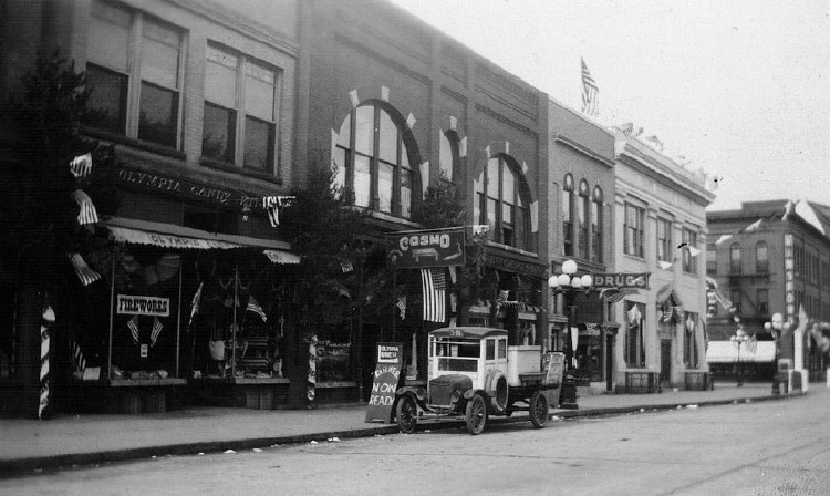
Looking southwest on Front Street. The first building on the left houses the Olympia Candy Kitchen, the next building is the Sleeper Block containing the Grand Theater in 1910 and the Cosmo Billiard Hall in 1920. The grand opening of the theater was held on April 18, 1910. The Grand had seating for 300, the stage was 16x24 feet and 14 feet high enabling it to accommodate any traveling vaudeville act of the day. The next building houses Dunn Drugs, next is the First National Bank at the corner of South 6th and Front Streets.
 |
| Front Street 1930 Source: Crow Wing County Historical Society |
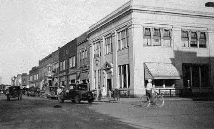
Looking southeast on Front Street near the corner of South 6th Street. The First National Bank is the first building on the right, three years before it was robbed by the Baby Face Nelson gang. The next building is what was left of the Sleeper Block after the fire of 1907, next is the Webb Block.
 |
| Front Street 1895 Source: Crow Wing County Historical Society |
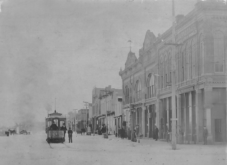
Looking east on Front Street from the corner of South 6th Street. One of the Brainerd Electric Street Railway cars is in the street. The street railway was built by Charles N. Parker. Construction began in September of 1892 and completed in May of 1893. The railway discontinued its operations in August of 1897. The first building on the right is the First National Bank; the second is the Sleeper Block.
 |
| Sixth Street 1906 Source: Crow Wing County Historical Society |
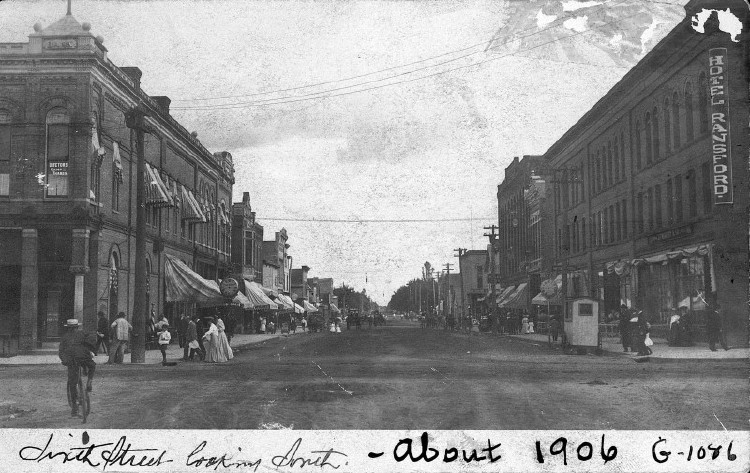
Looking south on South 6th Street. The first building on the right is the Ransford Hotel built by Ransford R. Wise in 1904, next is the Odd Fellows Building and the large building next is the Columbian Block built in 1893 by W. D. McKay (who also built the Iron Exchange Building in 1910-1911) and burned in October 1909. The first building on the left is the First National Bank built in 1882.
 |
| Sixth Street ca. 1920s Source: Crow Wing County Historical Society |
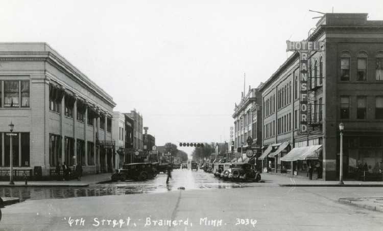
Looking south on South 6th Street. The building on the right is the Ransford Hotel built by Ransford R. Wise in 1904 and demolished on August 9, 1975. On the left is the First National Bank originally built in 1882 and remodeled in 1916, the first of four remodelings.
40-SIXTH STREET ca. Early 1950s
 |
| Sixth Street ca. Early 1950s Source: Crow Wing County Historical Society |
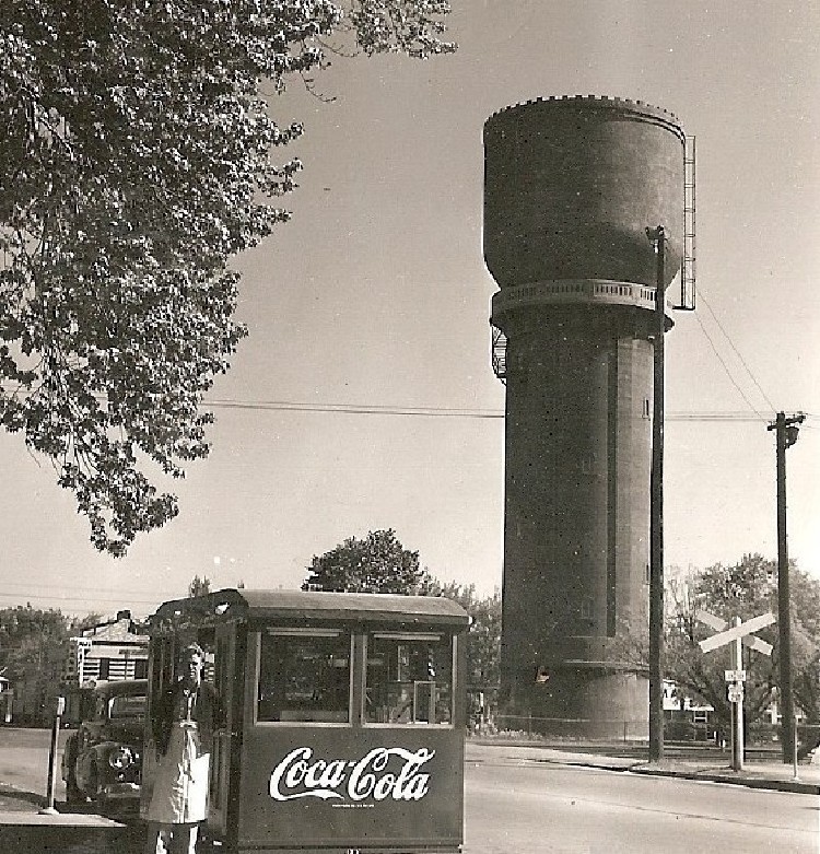
Looking northeast from near the corner of South 6th and Front Streets. The popcorn wagon is on the left; the water tower completed in 1920 is on the right and the building on the corner of 6th and Washington Streets is Van’s Cafe.
- 1-Laurel Street ca. 1920s; Laurel Street ca. 1920s; CWCHS; 750x458
- 1 Laurel Street 2017; Laurel Street 2017; John Van Essen; 400x250
- 2-Laurel Street 1946; Laurel Street 1946; CWCHS; 750x518
- 3-Laurel Street ca. 1930s; Laurel Street ca. 1930s; CWCHS; 750x452
- 4-Fifth Street 1936; Fifth Street 1936; CWCHS; 750x511
- 5-Laurel Street ca. 1930s; Laurel Street ca. 1930s; Minnesota Historical Society; 750x537
- 6-Laurel Street ca. 1940s; Laurel Street ca. 1940s; CWCHS; 750x439
- 7-Laurel Street 1938; Laurel Street 1938; CWCHS; 750x555
- 8-Laurel Street ca. 1958; Laurel Street 1958; CWCHS; 750x545
- 9-Laurel Street ca. 1939; Laurel Street 1939; CWCHS; 750x442
- 10-Laurel Street ca. 1930s; Laurel Street ca. 1930s; CWCHS; 750x459
- 11-Sixth Street ca. 1940s; Sixth Street ca. 1940s; CWCHS; 750x501
- 11a-Sixth Street ca. 1903; Sixth Street ca. 1903; CWCHS; 750x520
- 12-Laurel Street 1955; Laurel Street 1955; CWCHS; 750x419
- 13-Sixth Street 1912; Sixth Street 1912; CWCHS; 750x545
- 14-Sixth Street ca. 1940s; Sixth Street ca. 1940s; CWCHS; 750x568
- 15-Sixth Street ca. 1920s; Sixth Street ca. 1920s; CWCHS; 750x479
- 16-Laurel Street ca. 1940s; Laurel Street ca. 1940s; CWCHS; 750x506
- 17-Laurel Street ca. 1910s; Laurel Street ca. 1910s; CWCHS; 750x483
- 18-Laurel Street ca. 1960s; Laurel Street ca. 1960s; CWCHS; 750x507
- 19-Laurel Street 1918; Laurel Street 1918; CWCHS; 750x479
- 20-Laurel Street ca. 1930s; Laurel Street ca. 1930s; CWCHS; 750x468
- 21-Laurel Street ca. 1940s; Laurel Street ca. 1940s; CWCHS; 750x597
- 21a-Laurel Street ca. 1964-65; Laurel Street ca. 1964-65; Julie Nesheim; 750x432
- 22-Seventh Street ca. 1920s; Seventh Street ca. 1920s; CWCHS; 750x553
- 23-Laurel Street ca. 1920s; Laurel Street ca. 1920s; CWCHS; 750x528
- 24-Laurel Street ca. 1930s; Laurel Street ca. 1930s; CWCHS; 750x418
- 24a-Laurel Street ca. 1970s; Laurel Street ca. 1970s; Sharon Christian, Postcard; 750x467
- 25-Laurel Street ca. 1900s; Laurel Street ca. 1900s; CWCHS; 750x472
- 26-Laurel Street ca. 1916; Laurel Street ca. 1916; CWCHS; 750x464
- 26a-Laurel Street ca. 1950s; Laurel Street ca. 1950s; Carol Specht Wermter; 750x441
- 27-Front Street 1901; Front Street 1901; CWCHS; 750x523
- 28-Front Street ca. Early 1900s; Front Street ca. Early 1900s; CWCHS; 750x653
- 29-Front Street ca. 1938; Front Street ca. 1938; CWCHS; 750x413
- 29a-Front Street 2017; Front Street 17 October 2017; Carl Faust; 750x263
- 30-Seventh Street ca. 1910s; Seventh Street ca. 1910s; CWCHS; 750x473
- 31-Front Street ca. 1920s; Front Street ca. 1920s; CWCHS; 750x443
- 32-Front Street ca. 1950s; Front Street ca. 1950s; CWCHS; 750x578
- 33-Front Street ca. 1910s; Front Street ca. 1910s; CWCHS; 750x427
- 34-Front Street ca. 1930s; Front Street ca. 1930s; CWCHS; 750x502
- 35-Front Street ca. 1910s; Front Street ca. 1910s; CWCHS; 750x448
- 36-Front Street 1930; Front Street 1930; CWCHS; 750x452
- 37-Front Street ca. 1895; Front Street 1895; CWCHS; 750x546
- 38-Sixth Street 1906; Sixth Street 1906; CWCHS; 750x473
- 39-Sixth Street ca. 1920s; Sixth Street ca. 1920s; CWCHS; 750x452
- 40-Sixth Street ca. Early 1950s; Sixth Street ca. Early 1950s; CWCHS; 750x781
Thanks to the following individuals and organizations who made this website possible:
Kitchigami Regional Library
Jolene Bradley
Crow Wing County Historical Society
Carl Faust
Pam Nelson
John Van Essen
Researched and Compiled by Ann M. Nelson. Last Update: 17 March 2018
